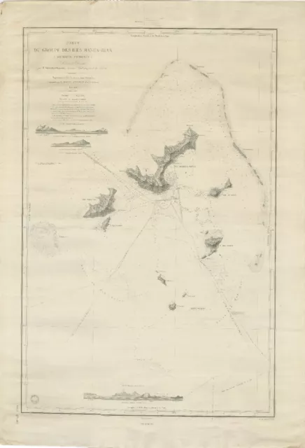
Large Chart of the Gambier Islands, Tuamotu Archipelago, French Polynesia
$2,530.00 Buy It Now or Best Offer, $40.00 Shipping, 14-Day Returns, eBay Money Back Guarantee
Seller: bartele-gallery ✉️ (227) 100%,
Location: Langweer, NL,
Ships to: WORLDWIDE,
Item: 115732054911
Large Chart of the Gambier Islands, Tuamotu Archipelago, French Polynesia.
Antique map titled 'Carte du Groupe des Iles Manga-Reva (Archipel Pomotou)'. Large chart of the Tuamotu Archipelago, French Îles Tuamotu, also called Paumotu, island group of French Polynesia, central South Pacific Ocean. This map focuses on the Gambier Islands, French Îles Gambier, also called Mangareva Islands, southeasternmost extension of the Tuamotu Archipelago of French Polynesia in the central South Pacific. The principal inhabited group of the Gambiers comprises the volcanic islets Mangareva (Magareva), Taravai, Akamaru, and Aukena.
Condition: Good. General age-related toning, shows minor wear. Blank verso. Please study image carefully.
Date: 1838
Overall size: 72.7 x 105 cm.
- Condition: Good. General age-related toning, shows minor wear. Blank verso. Please study image carefully.
- Type: Topographical Map
- Country/Region: French Polynesia
PicClick Insights - Large Chart of the Gambier Islands, Tuamotu Archipelago, French Polynesia PicClick Exclusive
- Popularity - 0 watchers, 0.0 new watchers per day, 398 days for sale on eBay. 0 sold, 1 available.
- Best Price -
- Seller - 227+ items sold. 0% negative feedback. Great seller with very good positive feedback and over 50 ratings.
People Also Loved PicClick Exclusive
![1683 Mallet. Isles des Larrons [Marianas Islands / Archipelago of St. Lazare] 1683 Mallet. Isles des Larrons [Marianas Islands / Archipelago of St. Lazare]](https://www.picclickimg.com/IN0AAOSwsPxkhFjD/1683-Mallet-Isles-des-Larrons-Marianas-Islands.webp)
1683 Mallet. Isles des Larrons [Marianas Islands / Archipelago of St. Lazare]
$42.00 Buy It Now 6d 14h
1853 Polynesia Islands Of Ocean Map By H. Wilkies J. Rapkin colored Hawaii
$135.00 Buy It Now 6d 19h
1825 Philippe Vandermaelen Large Antique Map of Austral Islands French Polynesia
$165.00 Buy It Now 23d 23h
South Pacific Ocean. French Polynesia Cook Islands. US Navy sea chart 1895 map
$186.76 Buy It Now 4d 1h
Gambier Archipelago. French Polynesia 1885 old antique vintage map plan chart
$17.43 Buy It Now 25d 1h
